As the saying goes, the Internet is everywhere and nowhere all at once — until a team from the University of Wisconsin mapped it all out.
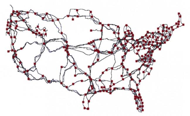
UW computer science professors and students created the first-of-its-kind map, released August 2015, that can be used to improve Internet security and performance.
Across the U.S., Internet data is carried across long distance fiber optic cables that connect major cities together as well as smaller cities and towns.
However, before a team of UW professors, students and external groups collaborated to create a map of this data, no one had a clear understanding of where the Internet infrastructure connections were, UW computer science professor, Paul Barford said.
The map is a representation of what are called “long hall links” in the Internet within the U.S. These links show the connections between major population centers, Barford said.
The data for the project was collected by looking at service infrastructure maps as well as other sources like county and state records, permits and licenses that are required to build and deploy this infrastructure, Barford said. This method was different from other data collection methods used in the past.
“The unique twist that we added … comes to not only finding map information but also verifying the information through these kinds of legal records and reports,” Barford said.
Though the process was tedious and cumbersome, the work was important, Barford explained. In order to improve Internet security, the details of the system have to be known.
Now that the infrastructure is known, additional infrastructure can be added to improve the robustness and identify places of weakness in infrastructure that could be subject to attacks, Barford said.
One of the major contributors to the project was Ramakrishnan Durairajan, a Ph.D. student who worked with Barford for the past four years.
Durairajan, joined the project his first day of graduate school. Finding it both interesting and challenging, Durairajan has worked on the project ever since.
“People just didn’t have the time and interest to look and gather the information like we have, so I happened to be the guy to agree to work on the project with a set of amazing colleagues and great guidance,” Durairajan said.
Durairajan has continually lead the project with advice from Barford, colleagues, graduate and undergraduate students.
Though the work for this project concluded a year ago, there have been possibilities of looking at networks outside the U.S., Barford said.
Additionally, Barford said he hopes to take the next step in using the map’s information and data archive to improve the Internet by working with service providers and other entities to deploy an infrastructure that is more secure and performs better.
“We have a couple of interesting projects underway right now that we hope to have manuscripts out on and I think this is a project that is going to have a very long line,” Barford said.
